 |
| acquired December 31, 2000download large image (12 MB, JPEG, 3660x3660) |
 |
| acquired October 30, 2015download large image (9 MB, JPEG, 3660x3660) |
Cambodia’s Forests Are Disappearing
earthobservatory.nasa.gov | 10 January 2917
Cambodia
has one of the fastest rates of forest loss in the world. In broad swaths of
the country, densely forested landscapes—even those in protected areas—have
been clear-cut over the past decade. Much of the forest has been cleared for
rubber plantations and timber.
Scientists
from the University of Maryland and the World Resources Institute’s Global
Forest Watch have been using Landsat satellite data to track the rate of forest
loss on a global scale. Though other countries have lost more acres in recent
years, Cambodia stands out for how rapidly its forests are being cleared.
Between
2001 and 2014, the annual forest loss rate in Cambodia increased by 14.4
percent. Put another way, the country lost a total of 1.44 million hectares—or
5,560 square miles—of forest. Other countries with accelerating rates of forest
loss include Sierra Leone (12.6 percent), Madagascar (8.3 percent), Uruguay
(8.1 percent), and Paraguay (7.7 percent).
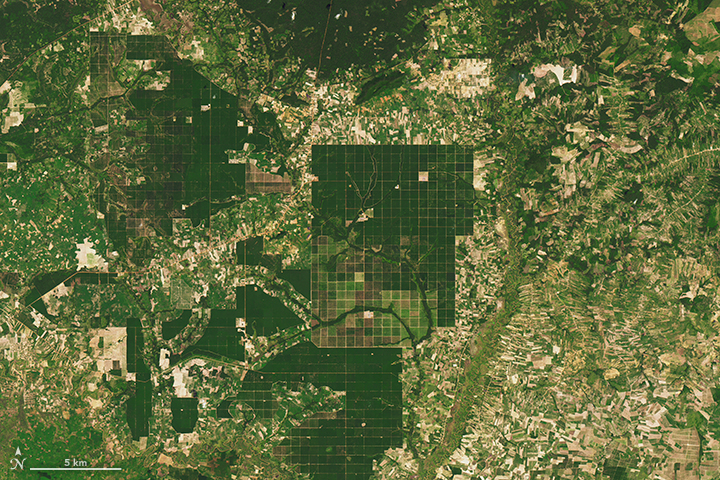
The
transformation of Cambodia’s landscape has been profound, as revealed by this
pair of Landsat images. The first image, captured by Landsat 7’s Enhanced
Thematic Mapper Plus on December 31, 2000, shows intact forest near the border
of the Kampong Thom and Kampong Cham provinces. On October 30, 2015, the
Operational Land Imager (OLI) on Landsat 8 captured the second image, in which
much of the forest has been replaced by a grid-like pattern of roads and fields
and by large-scale rubber plantations. Clear-cutting has also chewed away at
the edges of densely forested areas (dark green) and replaced them with exposed
soil, croplands, and mixed forests (brown and light green).
Researchers
working with Landsat data and other economic datasets have demonstrated that
changes in global rubber prices and a surge of land-concession deals have
played key roles in accelerating Cambodia’s rate of deforestation. Concession
lands are leased by the Cambodian government to domestic and foreign investors
for agriculture, timber production, and other uses. Researchers found that the
rate of forest loss within concession lands was anywhere from 29 to 105 percent
higher than in comparable lands outside the concessions.
Work by
Matthew Hansen and his University of Maryland Global Land Analysis and
Discovery (GLAD) lab has played a key role in revealing the scope of deforestation.
In 2013, the group published their first global map of forest change. The map
above, based on Hansen’s work, depicts the extent of forest loss throughout
Cambodia between 2000 and 2014. Much of it has occurred in the past five years.
In conjunction
with the World Resources Institute, GLAD has developed a new weekly alert
system: deforestation is detected by satellites with each new Landsat image,
and users can subscribe for email updates. The freely available alert system is
already operating for Congo, Uganda, Indonesia, Peru, and Brazil. The
researchers hope to have the system operating for Cambodia and the rest of the
tropics in 2017.
References and Further Reading
- Ahrends, A. et al. (2015, September) Current trends of rubber plantation expansion may threaten biodiversity and livelihoods. Global Environmental Change, (34), 48-58.
- Channel NewsAsia (2016, August 8) Illegal logging still threatens Cambodia’s forests despite ban: Special report. Accessed January 9, 2017.
- Davis, K.F. et al. (2015, September 21) Accelerated deforestation driven by large-scale land acquisitions in Cambodia. Nature Geoscience, (3), 772-775.
- Global Forest Watch (2015, September 2) Satellites Uncover 5 Surprising Hotspots for Tree Cover Loss. Accessed January 9, 2017.
- Global Forest Watch (2016, January 21) Video: Matt Hansen and Andrew Steer Discuss the Future of Forests. Accessed January 9, 2017.
- Grogen, K.et al. (2015, November) Cross-border forest disturbance and the role of natural rubber in mainland Southeast Asia using annual Landsat time series. Remote Sensing of Environment, (169), 438-453.
- Hansen, M. et al. (2016, March 2) Humid tropical forest disturbance alerts using Landsat data. Environmental Research Letters, 11 (3).
- Forest Trends (2015, July) Conversion Timber, Forest Monitoring, and Land Use Governance in Cambodia. Accessed January 9, 2017.
- LICADHO (2016, December 13) Cambodia Concessions. Accessed January 9, 2017.
- Nature (2016, October 4) Warning to forest destroyers: this scientist will catch you. Accessed January 9, 2017.
- Open Development Cambodia (2016, March) Forest Cover. Accessed January 9, 2017.
- The Cambodia Daily (2016, December 1) Eyes in the Sky Put Illegal Logging in Focus. Accessed January 9, 2017.
- The Cambodia Daily (2015, September 16) Cambodia Sees World’s Fastest Acceleration of Forest Loss. Accessed January 9, 2017.
- The Cambodia Daily (2016, October 28) (Un)protected Areas. Accessed January 9, 2017.
NASA Earth Observatory images by Joshua Stevens, using Landsat data from the U.S. Geological Survey and Global Forest Watch. Caption by Adam Voiland.
- Instrument(s):
- Landsat 7 - ETM+
- Landsat 8 - OLI
- Landsat 5 - TM


No comments:
Post a Comment